

You can find on this page the Dublin zipcodes map to print and to download in PDF. The Dublin zip code map presents postal codes, address lookup and code list of Dublin in Leinster - Ireland.

The Dublin postcodes map shows all the zip codes of Dublin. This zip code map of Dublin will allow you to easily find postal codes and address lookup of Dublin in Leinster - Ireland. The Dublin postcode map is downloadable in PDF, printable and free.
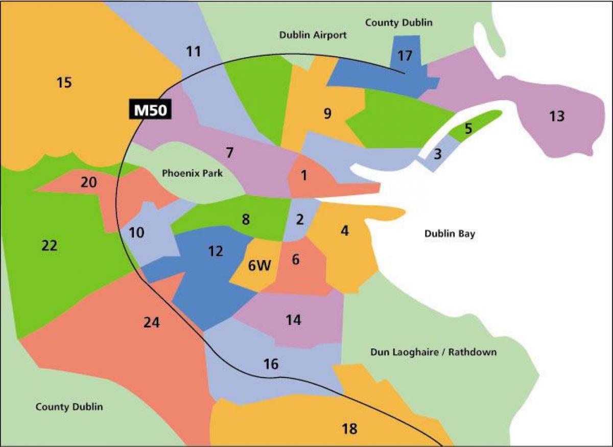
The postal district system was introduced in 1917 by the British government, as a practical way to organise local postal distribution. This followed the example of other cities, notably London, first subdivided into ten districts in 1857, and Liverpool, the first city in Britain or Ireland to have postcodes, from 1864. The letter "D" was assigned to designate Dublin as you can see in Dublin postcodes map. The new Irish government retained the postal district system, but district numbers were not used by the public until 1961, when they were added to street signs. Prior to 1961, street signs only displayed the street name in Irish and English.
The postal district appears with one or two digits (or in the case of one district, a digit and a letter) appearing at the end of addresses, e.g.: Dublin Orthodox Synagogue, 32 Rathfarnham Road, Terenure, Dublin 6W. In most cases, odd numbers are used for addresses on the Northside of the River Liffey, while even numbers are on addresses on the Southside as its mentioned in Dublin postcodes map. Exceptions to this are the Phoenix Park (along with a small area between the Park and the River Liffey), and Chapelizod Village which, although on the Northside, are parts of the Dublin 8 and Dublin 20 postal districts respectively. The numbering system is not used for some areas in County Dublin, such as Dún Laoghaire, Blackrock, Lucan or Swords, though it is used for other county locations, for example Firhouse, Foxrock, Kilshane, Knocklyon and Tallaght.
Street sign in Dublin, displaying name of the street in Irish and English, with postal district number. For example, an address in Dublin 4 might have the postcode D04 123 as its shown in Dublin postcodes map. This map shows the postal districts in and around Dublin City. In the Republic of Ireland, each property has a unique 7-digit code known as an Eircode. In Dublin City, the first three characters of a property Eircode is “D” followed by the postal district number, e.g. “D01” for Dublin 1 or “D18” for Dublin 18. Northern Ireland postal codes begin with “BT”.