

You can find on this page the Dublin metro map to print and to download in PDF. The Dublin metro map presents the network, zones, stations and different lines of the metro of Dublin in Leinster - Ireland.

The Dublin metro map shows all the stations and lines of the Dublin metro. This metro map of Dublin will allow you to easily plan your routes in the metro of Dublin in Leinster - Ireland. The Dublin metro map is downloadable in PDF, printable and free.
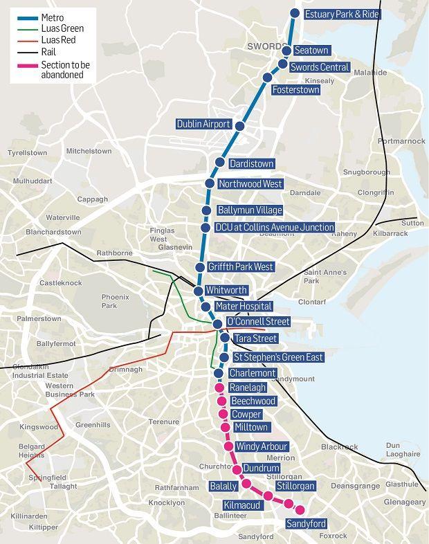
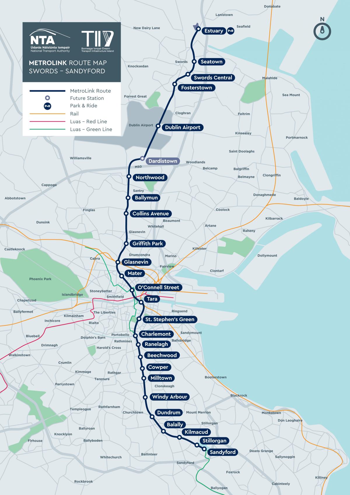
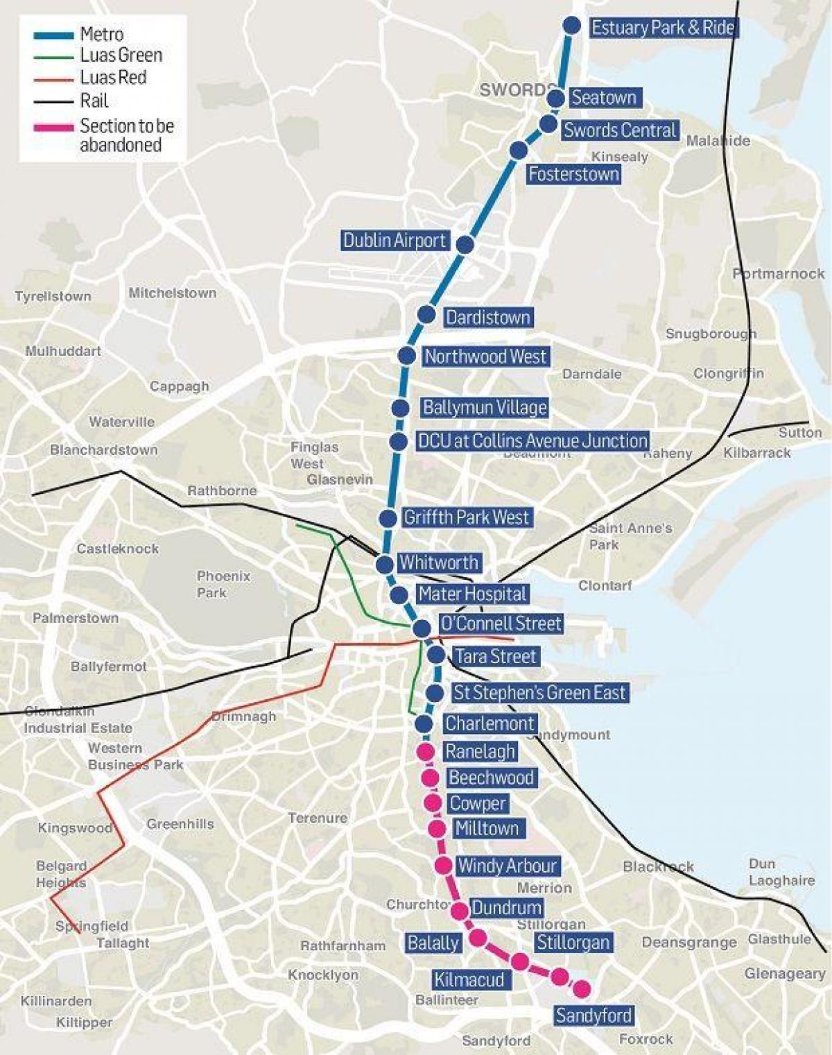
Metro North and Metro West will form a part of the planned rail infrastructure of Dublin, along with Luas trams, DART and Dublin Suburban Rail network. Metro North (Irish: Meitreo Thuaidh) is to run from St. Stephen Green to the airport and on to Swords, before ending at Belinstown as its shown in Metro map Dublin. Its route is planned to consist of deep bore tunnel under the airport and in the city, along with cut and cover tunnelling through the suburbs of Ballymun and Swords, along with surface running in non built-up areas, and a few elevated sections. On 16 September 2008, the RPA submitted a Railway Order Application to An Bord Pleanála. Metro North is currently planned to be 18 kilometres long. Metro West (Irish: Meitreo Thiar) is to run from an intersection with Metro North, just south of the airport at Santry, and from there pass through Blanchardstown, Liffey Valley, and Clondalkin before joining the Red Line of the Luas to continue towards Tallaght. Metro West is planned to be entirely above ground, at road level, with major junctions overpassed. Metro West is currently planned to be 25.5 kilometres long.
The Interconnector (Irish: Idirnascaire), also known as DART Underground, is a planned railway tunnel in Ireland, expected to run under the city centre of Dublin. The tunnel will allow for the expansion of the electrified DART and the Dublin Suburban Rail network, and connect these rail transport systems. It is intended to provide a link between the Docklands railway station at Spencer Dock (northern rail and western/north-western railway lines), Pearse Station (southern railway line) and Heuston Station (southwestern railway line) as you can see in Metro map Dublin. In addition, it will connect to the Luas light rail system, and the planned Metro. Metro North and DART Underground will interconnect at St Stephen Green station, the former supplying passengers to stations in the Northside whilst the latter runs along the Southside of the River Liffey, together providing underground rail access to much of the inner-city.
Metro West will serve the northern parts of Finglas via stops at the N2 and Meakstown as its mentioned in Metro map Dublin. When developing options for Metro West, the Railway Procurement Agency (RPA) considered routes south of the M50, serving Finglas more directly. These routes were not deemed feasible as they would have considerable impact on residential and commercial properties in the area, require additional bridges over the M50 and add considerable journey time to the route. Three potential routes for Metro North were published by the Railway Procurement Agenccy in February 2006. After public consultation, the RPA announced in October 2006 that the selected a routing known as the 'East/Central Combined Route'. A slightly updated route, with changes in proposed station names, some modifications to station locations, and details of proposed overground and underground routes through Swords was released by the RPA in March 2008.
The Dublin subway map shows all the stations and lines of the Dublin subway. This subway map of Dublin will allow you to easily plan your routes in the subway of Dublin en Leinster - Ireland. The Dublin subway map is downloadable in PDF, printable and free.
Dublin does not have a subway. Instead, its metro is made up of the Dublin Area Rapid Transport (DART) and commuter trains which are a quick way to get in and out of the city. The original idea for the two Metro lines in Dublin can be attributed to the November 2001 "Platform for Change" report by the Dublin Transportation Office (DTO). The purpose of the report was to come up with an integrated transportation strategy for the greater Dublin region. In its report, the DTO outlined plans for three Metro lines. The first was a North-South line which would run from Swords to Shanganagh via Dublin Airport, Finglas, Broadstone, the city centre, Ranelagh, Sandyford and Cherrywood as its shown in Dublin subway map. The second would link Tallaght West to Tallaght and then continue through the south-western suburbs of Dublin to the city centre. The third line would run in an orbital pattern, with a spur off the Swords-Shanganagh line at Finglas and then continue via Blanchardstown and Clondalkin to Tallaght, where it would connect with the other line.
The subway or metro option emerged as the preferred option, as it provides both an airport link and a commuter link as its mentioned in Dublin subway map. It has been described by the RPA as "an important commuter link for the communities and institutions of North Dublin City and County". Metro North (from Swords to St. Stephen Green) and Metro West were adopted as government policy with the launch of the Transport 21 programme in 2005. Both the LUAS, DART Underground and Dublin Metro will be included in the city future Integrated ticketing smartcard service. The aim is provide a unified service that together will provide the city of Dublin with a complete metropolitan rail system.
Metro North and DART Underground will interconnect at St Stephen Green station, the former supplying passengers to stations in the Northside whilst the latter runs along the Southside of the River Liffey, together providing underground rail access to much of the inner-city as you can see in Dublin subway map. Stations should also provide easy access to some of the city most popular tourist destinations, such as the O2 concert arena and the Point Village and Spencer Dock city quarters (currently under construction) via. the Docklands station; St Stephen Green park and Stephen Green Shopping Centre via. St Stephen Green station; Clerys department store, the historic GPO and the Spire of Dublin on O'Connell Street via. O'Connell Street station; Dublin Writers Museum and the Garden of Remembrance via. Parnell Square station; Trinity College, Dublin and College Green via. Pearse Street station; Guinness Storehouse and Phoenix Park via. Heuston Station