

You can find on this page the Dublin neighborhood map to print and to download in PDF. The Dublin districts map presents quarters, region, suburbs and surrounding area of Dublin in Leinster - Ireland.
The Dublin districts map shows all quarters and suburbs of Dublin. This district map of Dublin will allow you to discover areas and the region of Dublin in Leinster - Ireland. The Dublin districts map is downloadable in PDF, printable and free.
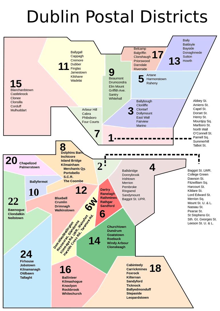
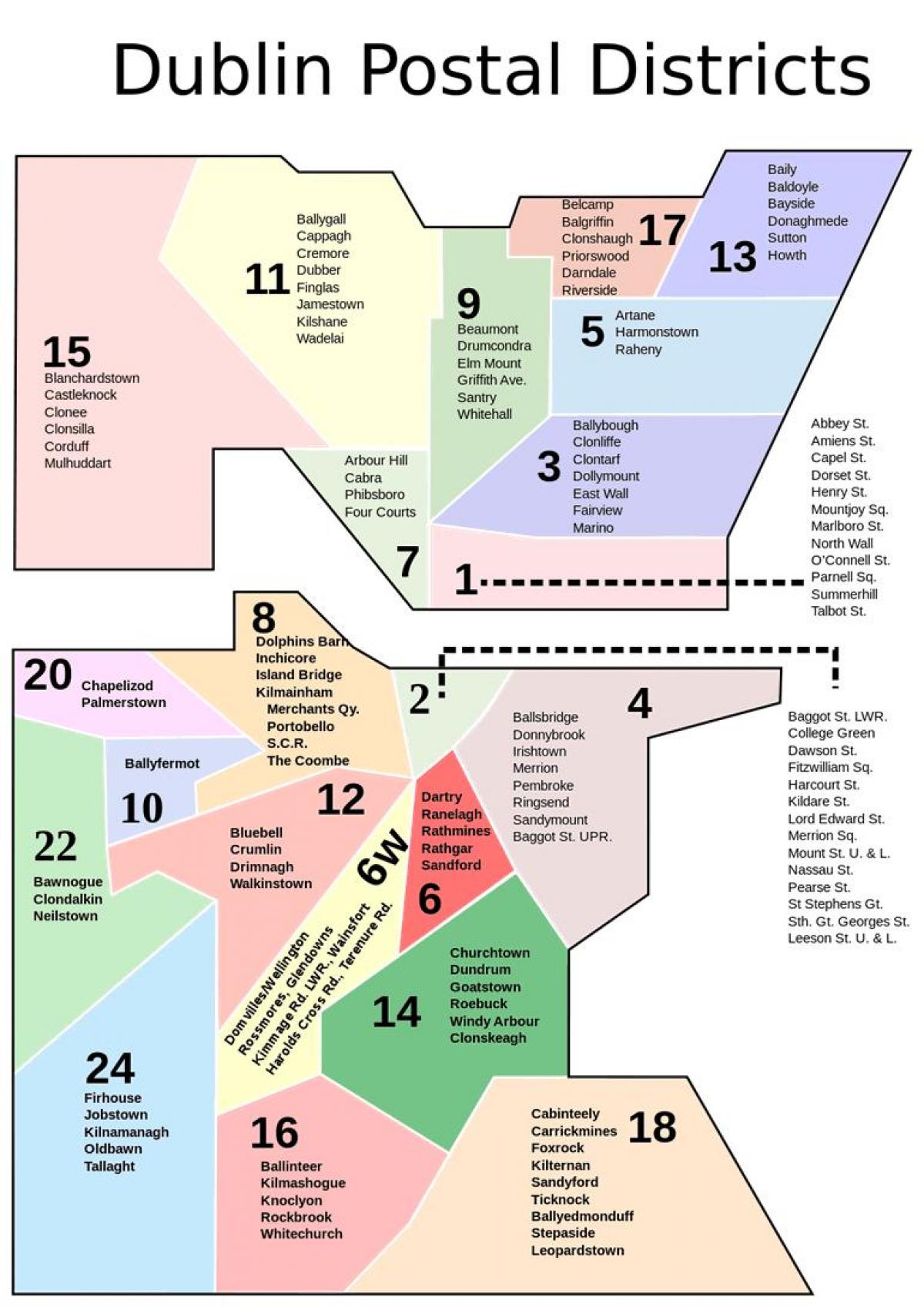
Dublin postal districts are used by Ireland postal service, known as An Post, to sort mail in Dublin. The system is similar to that used in cities in other European countries until they adopted national postal code systems in the 1960s and 70s. These may be incorporated into a new national postcode system that was to be introduced in 2011. Dublin 1 as its mentioned in Dublin districts map, includes most of the north inner city, including Abbey Street, Amiens Street, Capel Street, Dorset Street, Henry Street and Mary Street, Mountjoy Square, Marlborough Street, North Wall, O'Connell Street, Parnell Square, and Talbot Street. Dublin 2 encompasses most of the city centre south of the River Liffey and takes in areas around Merrion Square, Temple Bar, Grafton Street, Dame Street, Leeson Street and Wexford Street. Dublin 3 encompasses areas such as Ballybough, North Strand, Clonliffe, Clontarf, Dollymount, East Wall (including East Point), Fairview, most of Killester, and Marino. Dublin 4 includes Ballsbridge, Donnybrook, Irishtown, Merrion, Pembroke, Ringsend and Sandymount and contains the RDS grounds, Lansdowne Road stadium, and many embassies. Dublin 5 includes most of Artane, central Coolock, Harmonstown, Kilbarrack, and Raheny.
Dublin 6 includes Milltown, Ranelagh, Rathmines (including Dartry), and Rathgar). Dublin 6W includes Harold Cross, Templeogue, and Terenure as its shown in Dublin districts map. Dublin 7 includes Arbour Hill, Broadstone, Cabra, Grangegorman, Phibsboro, Smithfield, Stoneybatter; a key feature is the Four Courts complex. Dublin 8 includes Dolphin Barn, Inchicore, Islandbridge, Kilmainham, Merchants Quay, Portobello, South Circular Road, the Phoenix Park and The Coombe. Dublin 9 includes parts of Ballymun east of Ballymun Road (Shangan and Coultry), Beaumont, Donnycarney, Drumcondra, Elm Mount, Griffith Avenue, parts of Glasnevin (St Mobhi, Botanic Gardens and Met Éireann), Santry, and Whitehall. Dublin 10 includes Ballyfermot and Cherry Orchard. Dublin 11 includes most of Ballymun west of Ballymun Road (Sillogue, Balcurris, Balbutcher, Poppintree, Sandyhill and Wadelai), Dubber Cross, Finglas (including Ballygall and Cappagh), most of Glasnevin (Cremore, Addison, Violet Hill, Finglas Road, Old Finglas Road and Glasnevin Cemetery), Kilshane Cross, The Ward and Coolquay.
Dublin 12 includes Bluebell, Crumlin, Perrystown, Terenure, Drimnagh, and Walkinstown as you can see in Dublin districts map. Dublin 13 Baldoyle, Bayside, Donaghmede, Sutton, Howth and Ayrfield. Dublin 14 includes Churchtown, Clonskeagh, Dundrum, Goatstown, Rathfarnham and Windy Arbour. Dublin 15 includes Blanchardstown, Castleknock, Coolmine, Clonsilla, Corduff, Mulhuddart, Tyrrelstown and the Dublin part of Clonee, as well as Ongar. Dublin 16 includes Ballinteer, Ballyboden, Kilmashogue, Knocklyon and Rockbrook. Dublin 17 includes Balgriffin, most of Coolock, and Belcamp, Darndale and Priorswood. Dublin 18 includes Cabinteely, Carrickmines, Foxrock, Kilternan, Sandyford, Ticknock, Ballyedmonduff, Stepaside, and Leopardstown. Dublin 20 includes Chapelizod, and Palmerstown. This is one of only two postal districts to span the Liffey. Dublin 22 includes Clondalkin, Rowlagh, Quarryvale and Liffey Valley, and Neilstown. Dublin 24 includes Firhouse, Jobstown, and Tallaght (see that article for component estates / localities, such as Kilnamanagh).